

SCGI MASTER PROGRAM
- About Program
- Student Learning Outcome
- Why SCGI?
- Career Path
- Curriculum Structure
- Course Description
- Admission Requirements
About Program
VISION
To provide twenty-first century education through a multi-dimension academic journey in Space Technology and Geo-informatics to students who will be future global leaders.
BACKGROUND
The Sirindhorn center of Geo-Informatics Master’s Program is collaboration amongst Wuhan University: China, Burapha University: Thailand, and GISTDA (under Ministry of Science and Technology: Thailand) to offer a Double Master Degree on Geo-Informatics and Space Technology. The program has been designed to prepare students’ capability for the demands of spatial solutions with professors from Wuhan University of the Peoples Republic of China and Burapha University and other resources from GISTDA, Ministry of Science and Technology of Thailand.
Based on the content of this program, capacity building and technology transfer between students and professors, between China and Thailand will tremendously increase. The aim of the program is not only to increase the capability of the students and personnel but also to establish and expand the network of academic knowledge and research collaboration in the region and to deliver the new methods / data / products to ASEAN countries which can be beneficial to the management of the environment and natural resources in the region. The uptake of new innovations in space and geo-informatics technology can lead to regional sustainability.
The Geo-informatics Master’s Program aims at preparing technicians who possess deep preparation and strong attitude to solve problems relevant to spatial information, with a special concern on geo-referenced environmental data. Therefore, their competences are interdisciplinary and range from Environmental to Computer Science Engineering. More precisely, they will acquire the following skills, both on the methodological and practical point of views. The following expertise may be included:
- Computer infrastructures, needed to manage these data in the framework of the digitalization and automation of public and private sectors, even by Internet and Web technologies.
- Acquisition and geo-referencing,
- Spatial information managing:
- Methodologies and instruments to model and analyze environmental phenomena.
- Analysis, classification and processing,
- Advanced technologies for Big Geo-data and internet of Places.
- Archiving, representation, publication and distribution.
The program poses the basis on the fundamental knowledge, both in Environmental and in Computer Science that have been acquired at the Bachelor level and proposes new highly specialized topics relevant to Geo-informatics. The study program is fully offered in English, accordingly to international program of Wuhan University and Burapha University.
Graduates will be able to propose original solutions to manage and process spatial information and proficiently interact with multidisciplinary groups of experts in Environmental and Computer Science fields. Their knowledge spans the general management of spatial information, with a particular attention to geo-referred environmental data; from a Computer Science side, he/she is able to analyze, design and implement solutions to complex geospatial problems. The acquisition of these capabilities requires the knowledge of all the methodological and practical topics that allow identifying, model, and solving the typical Geo-informatics problems. The evaluation of the knowledge is a continuous process during each course that starts with classwork and laboratories and ends with the examination or project delivery.
SCGI MASTER PROGRAM
 Sirindhorn Center for Geo-informatics (SCGI) Master program stands designed to prepare personal capability for the demands of spatial solutions in the area of education under the collaboration of The State Key aboratory of Information Engineering in Surveying, Mapping and Remote Sensing, Wuhan University (LIESMARS), Burapha University (BUU) and Geo-Informatics and Space Technology Development Agency (GISTDA), attached to the Ministry of Science and Technology of the Kingdom. of Thailand. SCGI serves as the international institute for research and knowledge/ technology transfer in space technologyand geo-informatics.
Student Learning Outcome
Objective of the Master of Science in Geo-informatics is to produce graduates with in-depth knowledge, ability and leadership to leverage experience in the field of in Geo-informatics and related technology such experience can be used to solve problems and plan for urban planning and industrial geography, physical geography, disaster prevention and mitigation, etc.
By graduation, graduates of this course will have the following features :
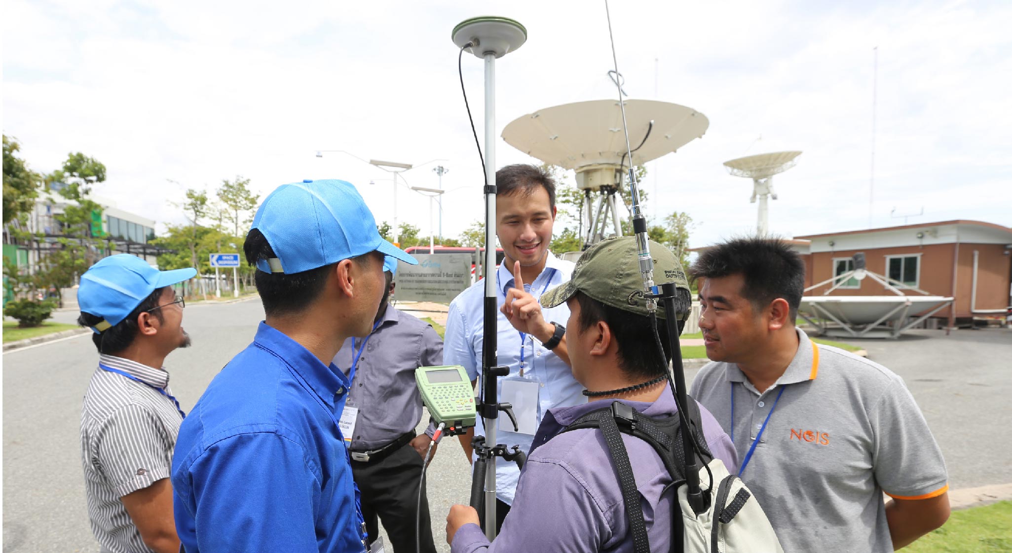
- To understand the theory and technology of Geodesy, Modern photogrammetric, Remote sensing, Cartography, Geographic information systems, Global navigation satellite system (GNSS) and survey engineering.
- To use and operate a very wide variety of state-of-the-art technology, such as laser scanners, GNSS, etc.
- To apply their knowledge of these system to applications in various domains of geo-data handling.
- To analyze, synthesize and integrate to the new knowledge for developing and solve problems using geo-informatics.
Wuhan University, the world class University
 Wuhan University is among the top 10 universities in China and well known for high-quality education.
It has a long tradition of actively engaging in international exchange and cooperation. It has developed partnerships and collaborations with over 400 universities and research institutions in more than 70 countries and regions. Located along the bank of East Lake and at the foot of Luojia Mountain, Wuhan University
is appreciated to be the most beautiful university in china, especially for its cherry blossom garden in the spring. The university is heavily wooded and green, with fragrant flowers everywhere year-round The beautiful natural
scenery, together with the ancient style buildings, forms a beautiful, peaceful and pleasant campus.
Wuhan University is among the top 10 universities in China and well known for high-quality education.
It has a long tradition of actively engaging in international exchange and cooperation. It has developed partnerships and collaborations with over 400 universities and research institutions in more than 70 countries and regions. Located along the bank of East Lake and at the foot of Luojia Mountain, Wuhan University
is appreciated to be the most beautiful university in china, especially for its cherry blossom garden in the spring. The university is heavily wooded and green, with fragrant flowers everywhere year-round The beautiful natural
scenery, together with the ancient style buildings, forms a beautiful, peaceful and pleasant campus.
The State Key Laboratory of Information Engineering in Surveying, Mapping and Remote Sensing, (LIESMARS), Wuhan University, was founded in 1989, and the first state key laboratory in the field of surveying and mapping in China. In evaluations conducted by the Ministry of Science and Technology, LIESMARS was consecutively ranked “Excellent” in 2000, 2005, 2010, and 2015, and was presented with the Golden Bull Award in 2004. LIESMARS ranked first in the world in the surveying and mapping discipline and ranked first in China, and in geography, it is at the forefront.
Globally-recognized professors and Innovative research programs
The Master program draws a wide range of renowned global experts. Our award-winning faculty are publishers in top tier journals and consistently invited to give presentations at the profile conferences. Professors from LIESMARS are their innovative research team in earth observation and navigation technologies at Wuhan University, led by three academicians, Prof. Li Deren, Prof. Liu Jingnan and Prof. Gong Jianya, won the National Science and Technology Progress Award in 2014. This visibility has allowed for research collaborations with departments and research institutions. The nationally and internationally esteemed faculty provide guidance, instruction and potential thesis research chairs to students in the master program. This program will challenge The Students academically through advanced academic experiences with globally recognized professors.
Get a double specialization master’s in a short time
LIESMARS, Wuhan University, China and Burapha University, Thailand; Master of Science in Geo - informatics. Two of the leading academic institutions in their respective countries,are joining forces to offer students a new double degree programs in 2018. The new programwill enable students from the two prestigious institutions to pursue complementary studiesin Geo-informatics. With a double degree Master’s program, students will divide study time into two periods, each belonging to one of the universities. The students will conduct a singlegraduation thesis, in collaboration with both universities, where the students will have advisors from the two organizationsat the same time. This will also enable students to receive a Master of Science in Geo-informatics from Burapha University and Wuhan University.
Career opportunities in the prestige organizations
Wuhan University has cultivated professional talents in various occupations. GISTDA is a pioneer in developing applications and solutions for both public and private sectors. With their support, the program shall offer students the opportunities of an international internship / exchange program / study trips that will be a passport to pursuea successful career in top international organizations.

Broaden your international and inter-personal skills
Students will live on two different campuses and gain international experiences, therefore sharpening their international profile. An international study environment will help form an international network in China, ASEAN and beyond, which is necessary for their career.
Career Path
Due to the broad spectrum of basic training and the wide variety of thematic and interdisciplinary areas of specialization that will be part of the curriculum, graduates can apply their knowledge and skills in several domains. Graduate students who wish to pursue a career in academics can explore the opportunity in continuing the world class PhD program at LIESMARS, Wuhan University. The State Key Laboratory of Information Engineering in Surveying, Mapping and Remote Sensing (LIESMARS) produced PhDs graduates that then become tenured professors at universities around the world.

Graduate students may also pursue a career in the Geo-Information industry with companies such as ESRI, PLANET, Google, MapInfo, DJI, Digital Globe to name a few. As the graduate will have completed an international program, they will have access to a larger market share of companies including those in China. Specific areas of work include: positions in companies of geo-information (data analyzing, Big data, data processing, etc.), in companies in the fields of surveying engineering, photogrammetry, remote sensing and geo-visualization, geographicinstitutesand cartographic institutions in general, in areas of mess media and information graphics, computer system consulting and navigation system, and in planning departments. Graduate students may also choose to pursue a career with the government sector back in their home country. This program will provide them with a foundation to assess and make decisions based on geographic information in area of water management, urban planning, disaster management, etc.
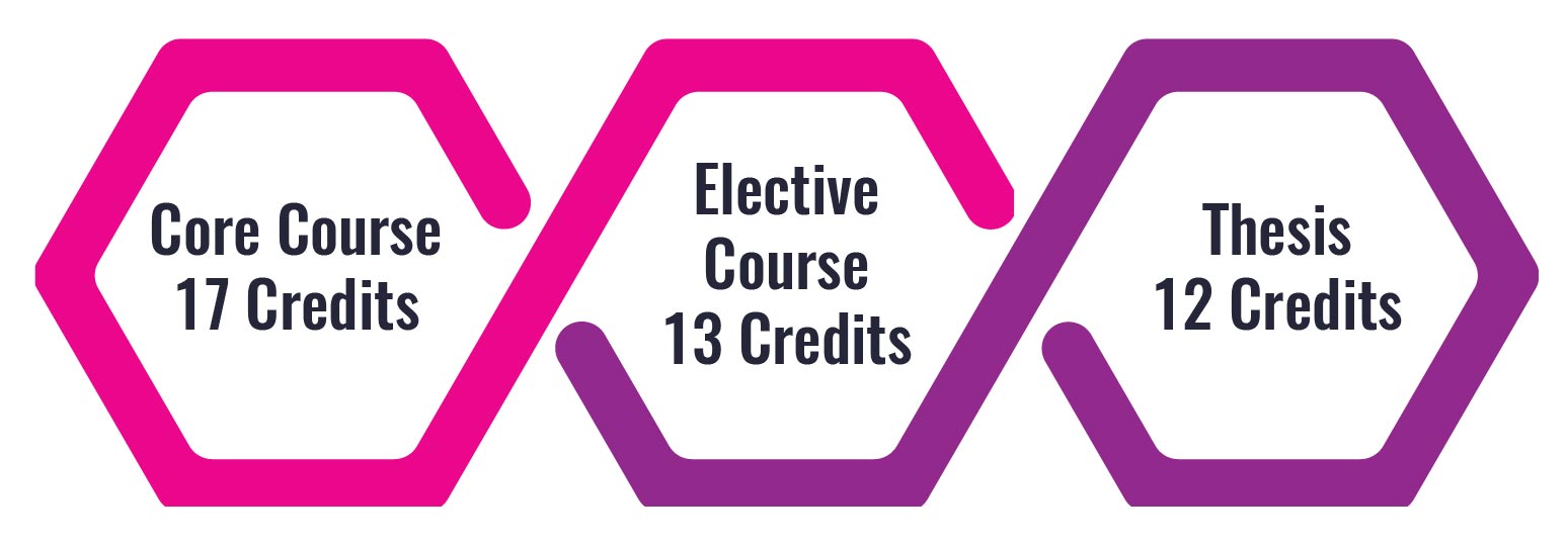
Curriculum Structure
Study Plan
The Master of Science in Geo-informatics (SCGI) offers a study plan with its own requirements. The duration of the course is for 2 years with 42 credits. Students study the 1st year at SCGI with 2 semesters; 1st semester between August – December and the 2nd semester between January to May. In the 2nd year students go to LIESMARS, Wuhan University in China and continue with another 2 semesters; 1st semester between September to January and 2nd semester in February to July.
| Year/ Semester | Course Name | Credit | campus |
| 1/1 | Remote Sensing | 3 | SCGI |
| Applications of Geographic information System | 3 | ||
| Global Navigation Satellite System | 3 | ||
| Elective Course | 3 | ||
| 1/2 | Seminar for Graduate student I | 1 | SCGI |
| Research and Environment Management Information System | 3 | ||
| Elective Course I | 3 | ||
| Elective Course II | 3 | ||
| 2/1 | Comprehensive Chinese in daily life | 2 | WHU |
| Outline of China | 2 | ||
| Thesis Proposal | 4 | ||
| Elective Course I | 2 | ||
| Elective Course II | 2 | ||
| 2/2 | Thesis | 8 | WHU |
| Total | 42 | ||
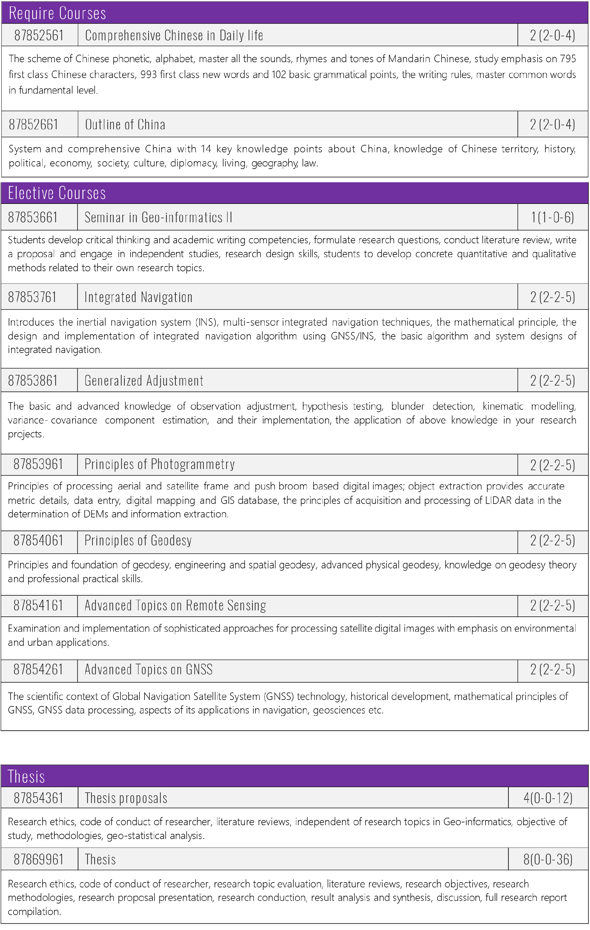
Course Description
Faculty of Geo-informatics, SCGI and Burapha University
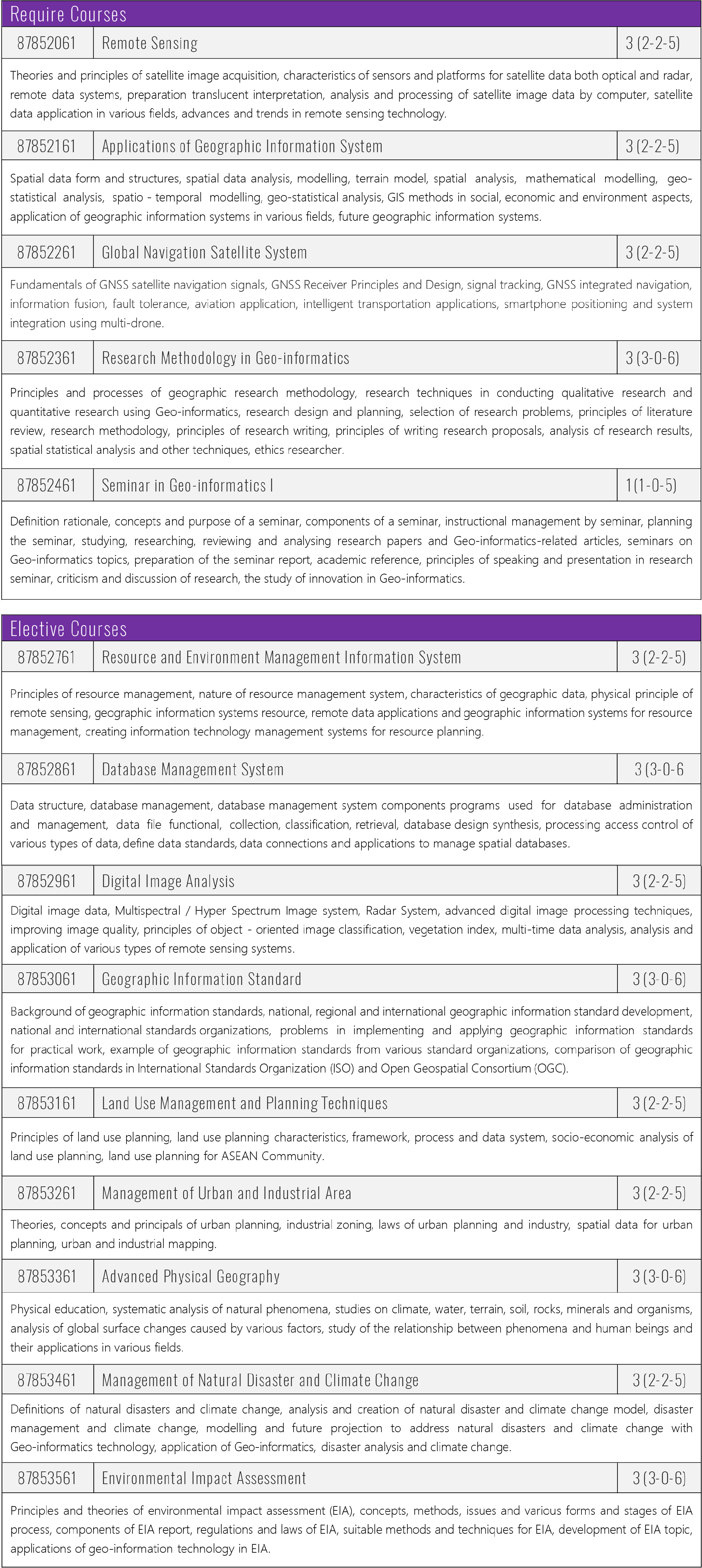
LIESMARS, Wuhan University
Admission Requirements
- Fully filled Application form with photographs. Application form filled out or downloaded at http://scgi.gistda.or.th or http://e-admission.buu.ac.th
- Applicants must be under the age of 45. If the applicant is over 45 years, he / she must have at least 3 years working experience in Geo-Informatics field
- Applicants must hold a bachelor degree in Geography, Geo-Informatics, Aerospace Engineering, Electrical Environmental Engineering, Mathematics, Physics, Informatics or Other Related Sciences.
- Certified copy of transcripts.
- Applicants must have a GPA of at least 2.75.
- Thai and foreign applicants with English certificates for TOEFL (iBT) overall score of 57 or above or IELTS score of 5.5 or above or BUU-GET 60 or above.
- Two letters of recommendation from persons who are familiar with the applicant’s academic background and / or work experience, preferably an instructor(s) with academic rank for university or head of the unit in the work place of the applicant.
- A copy of a valid passport and / or Thai identification card.
- A copy of current residency document.
- A study plan, 800 words describing the applicants proposed plan on how she / he will apply the knowledge gained for the future.